RITIS Overview
Overview: The Regional Integrated Transportation Information System
Website: RITIS
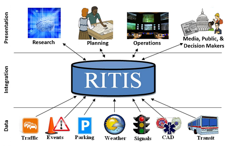
The Regional Integrated Transportation Information System (RITIS, developed by The CATT Lab, The University of Maryland) is an automated data fusion and dissemination system that provides an enhanced overall view of the transportation network, the real-time systems that fuse and integrate hundreds of Gigabytes of data per day in real-time from emergency operations centers, transportation management centers, thousands of sensors, CCTV cameras, and sub-systems throughout the country. Participating agencies are able to view transportation and related emergency management information through innovative visualizations and use it to improve their operations and emergency preparedness. RITIS also uses regional standardized data to provide information to third parties, the media, and other traveler information resources including, websites, paging systems, and 511. There are three main RITIS components including:
- real-time data feeds,
- real-time situational awareness tools,
- archived data analysis tools.